What to Expect
Who should use the track?
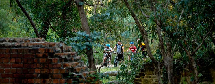
The Goldfields Track is a natural bush track. It is for bushwalkers and mountain biking, and a note for those cycling, it is not recommended for hybrids.
The track ranges from easy to difficult (at the moment it does not have an official rating due to its variability) but it has something to appeal to all levels of fitness and skill, and can be enjoyed by all. However, for anyone that is not so fit or skilled (both walkers and riders) it is recommenced to attempt shorter distances on any given day.
The ups and downs.
The track is undulating and quite rocky in some sections, so will often provide more challenges (and fun) than you might expect. For mountain bikers the track is incredibly varied, with just about every conceivable form of climb, descent and flat track imaginable rolling under your wheels at some point.
When we say undulating, we are not joking! It is generally recommended to travel from south to north (Buninyong/Ballarat to Bendigo). This doesn’t avoid the hills, but there are more ups than down if you go the other way! Have a look at the elevation below to give you some idea of what to expect.
Travelling to and from.
You can easily make you way to the Goldfields Track by car or public transport.
If you are driving, all the key towns along the way are well serviced by major freeways and highways. Along the track itself, especially relevant for the walkers, there are plenty of car access points, so if you want to break the track into manageable sections, there are numerous options for pick-ups and drop-offs.
VLine trains will take you to Ballarat, Creswick, Castlemaine and Bendigo. For walkers, VLine has a coach service to Daylesford and Harcourt. Please note, bikes are not allowed on the VLine coach services. From Melbourne a great car free option is to catch the train to Ballarat, spend however many days making your way to Bendigo, then catch another train home again. Bikes are allowed on off-peak train services so many riders find this a great way to experience the track.
If you intend to explore the track this way, make sure you talk to your accommodation provider about adding pick-up and drop-off support to your total overnight package, they can even help out with packed lunches.
Show me the way.
Before you hit the track, make sure you get a map. The track is very well signposted, but even so, you must have a proper map to follow. More info at the Get A Map page.
If you don’t feel like finding your own way there are some Goldfields Track partners that offer guided tours of the track. Do a search for them on the What To Do page. Or join the Great Dividing Trail Association on one of their guided walks. They run a program each year, with walks of varying lengths and difficulty in areas along the track. Download their latest program here.
When to go?
The Goldfields Track can be enjoyed all year round, but keep in mind central Victoria has frosty mornings in winter and can be quite hot in summer. And no matter what time of the year you should always be prepared for a change in the weather, and reduced visibility in the higher areas which can make it difficult to see the marker posts.
If walking in winter be prepared for a wet track and a bit of mud. Summer, conversely be prepared for hot days. You should not use the track on total fire ban days.
The weather is most reliable in autumn, and in spring many parts of the track are home to beautiful wildflower displays. During these seasons local land managers sometimes conduct planned burns (to manage future bush fire risk). While these burns do not necessarily close the track, depending on the amount of smoke they may lessen your enjoyment. You may want to schedule your visit to avoid these times. Information on planned burns is available here. Simply search by town name, i.e. if you plan to be on the Dry Diggings Track section, search by Daylesford and by Castlemaine.
The Emergency Vic page has up to date information on any emergencies and warnings, particularly necessary if you plan to be on the track during the fire season.
If visiting on weekends or school holidays, it is recommended you book your accommodation in advance as the area is a popular holiday destination.
Four legged friends
Much of the Goldfields Track runs through land managed by Parks Victoria, the rest is managed by either Dept. of Environment, Land, Water and Planning (DELWP) or local government. So if you want to travel by horseback, or take your dog you need to follow the guidelines of those land managers. As a rule, horses are allowed on designated vehicle tracks, but not on designated walking or cycling tracks. There are some sections of the track that follow vehicle tracks, but the majority is on walking and cycling tracks.
Dogs, if on a lead, are allowed in regional and state parks, and in central Victoria in many sections of the Box-Ironbark National Parks. The majority of the Goldfields Track is in these parks, so your faithful companion can be by your side. The section of track they are not allowed is through the Castlemaine Diggings National Park. This covers much of the Dry Diggings Track – roughly from Porcupine Ridge Road to Castlemaine, and the first section of the Leanganook Track from Castlemaine to Golden Point. To be sure of details check the Parks Victoria Park Notes for any of the areas you intend to visit with your dog.
A quick Goldfields Track history lesson
The Goldfields Track used to be known as the Great Dividing Trail. It was created by the Great Dividing Trail Association (GDTA) in the early 1990s, following a dream of the GDTA’s first President, Barry Golding to create a trail that followed the creeks, gullies and ridges of the Great Divide. The GDTA, all volunteers, did an extraordinary job, to work with the land managers to create the Great Dividing Trail. It (almost) followed the Goldfields Track route from Ballarat to Bendigo that we have today, and includes another arm, linking Daylesford to Bacchus Marsh – the Lerderderg Track.
In 2009, Goldfields Tourism Incorporated secured a significant Federal Tourism Development Grant and worked with the GDTA, local councils en-route, and the land managers to upgrade the track to the shared use bushwalking and mountain biking track you see today. The upgrade included a new name, lots of new infrastructure – signage, bridges, steps and works to make the track safe for shared use, and a website.
The GDTA is still active in their use and support of the track, providing invaluable maintenance assistance at the track’s southern end, part of the Goldfields Track Development Project Committee and of course enjoying the track and encouraging others to do the same.
So if you sometimes see the term “Great Dividing Trail” you’ll know why.